Malthi, Messenia (1926–1929, 1933–1934, 1952, 2015–2017)
2020-04-24
During the Bronze Age a flourishing community existed on and around Malthi, the northern spur of the mountain range of Ramovouni, located a few kilometers from the village Vasiliko in northern Messenia. On the ridge itself, c. 100 meter above the valley floor, a fortified Middle to Late Bronze Age settlement was situated. From here it had a splendid view of the valley which offered easy communications between inland Peloponnese and the coast. Below the mountain spur several tholos tombs as well as a second, so far almost completely unexplored, Late Bronze Age settlement have been located. Furthermore, throughout the valley and its surrounding foothills, around 16 sites from the Middle Bronze Age have been identified, suggesting that the landscape was densely inhabited. Thanks to extensive works both in the past and in more recent years Malthi provides an unusual opportunity to study a fully-excavated, well-preserved Bronze Age settlement with few contemporary parallels on the Greek mainland.
Excavations
Work began in 1926 as Swedish archaeologist Natan Valmin came to the region and was shown two tholos tombs just west of the Malthi acropolis, near the small modern village of Malthi (former Bodia). Valmin excavated these later the same year, while a third tholos tomb was identified but destroyed before there was time to explore it. In 1927 he initiated excavations of the settlement on top of the acropolis. Work continued there in 1929, 1933 and 1934, uncovering the area in its entirety. In 1936 a building in the lower settlement, dating to the Late Bronze Age, was excavated. During all excavation campaigns, Valmin searched in vain for chamber tombs in the region.
Between 2015 and 2017 Michael Lindblom and Rebecca Worsham re-initiated work at the fortified settlement on the mountain spur, aiming to correct certain errors in the dating of the archaeological strata, as well as in the published plans of the site. These earlier misinterpretations had hampered the use of Malthi as an example in Bronze Age settlement studies. During these campaigns the remains were cleared and re-documented using modern methods. Additionally, limited excavations were carried out in order to clarify the stratigraphy and enable the re-evaluation of the site and its chronology.
Tholos tombs
In the valley below the fortified settlement the so-called Tholos I had already been robbed when it was excavated in 1926. The material that remained included a mixture of Mycenaean pottery sherds and later fragments. The diameter of the circular chamber was 6.85 m and the height 5.80 m. Tholos II, also explored in 1926, was partly collapsed at the time of excavation. This tomb too turned out to have been robbed. Both tombs were obviously cut out from the cliff and not built directly on flat ground as Valmin had thought. In 1927 Valmin excavated two more tholoi: one west of Kopanaki and another between Vasiliko and Bouga-Kallirrhoi.
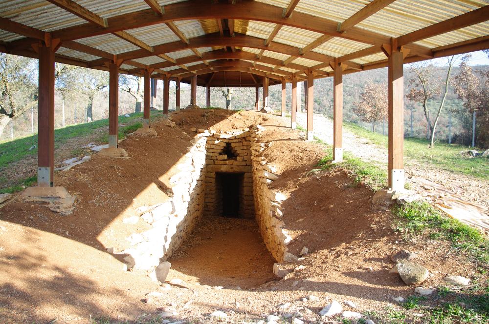
Fig. 2: Tholos 1, below the fortified settlement.
The Malthi settlement
The excavation of the settlement on the ridge started in 1927 and continued in 1929 and 1933–1934. During these years the entire walled settlement was uncovered, measuring 140×80 m (1.12 ha). Valmin stated, erroneously, that the earliest habitation was Neolithic, and named it Dorion I. Dorion II was, according to Valmin, larger and would belong to the Early Bronze Age. The wall around the settlement was supposedly erected during Dorion IV, the Middle Bronze Age. This habitation continued down into Mycenaean times. For the Middle Bronze Age, Valmin described how the Dorion IV settlement was divided into three separate parts: the central area where the architecture seemed to be of a more monumental character with workshops in the northern part, the area running along the interior of the wall, and the empty areas where there was no habitation.
Recent work, however, shows that the earliest habitation at Malthi cannot be dated earlier than the Middle Bronze Age. The pottery which Valmin called coarse ‘Adriatic Ware’ and which he found throughout the layers in the habitation beginning in the so-called Neolithic settlement, has proved to be typical for the local Middle Bronze Age in Messenia. The encircling wall is now dated to the Late Helladic period.
Within the walls 50 tombs have been excavated, 48 by Valmin and two in recent years, located beneath and between buildings. They are either simple pit graves or cist graves, the sides of which consisted of stone slabs or were built by smaller stones. Single burials were most common, although some of the graves held two individuals, others several. Two of the graves held no human bones. Nine of the burials were adults and the rest were children, among those the two that were explored during the recent excavations. The body in the first (in room D43) was truncated with only the skull left in situ and no grave goods. The second burial (in room D45) was a pit grave laid on and within a stone packing. The human remains were in a poor state of preservation, as was the case generally at the site, with a spindle whorl found by the skull as the only potential grave goods.
Recent fieldwork at Malthi
The first goal when fieldwork was resumed at Malthi in 2015 was to update and publish an accurate plan of the preserved settlement architecture using modern technologies. To that end, the site was re-mapped with a differential GPS with which points were acquired every 30–50 cm along preserved faces of all architecture visible within the fortification wall. Additionally, a digital 3D-model of the site was created using a terrestrial laser scanner.
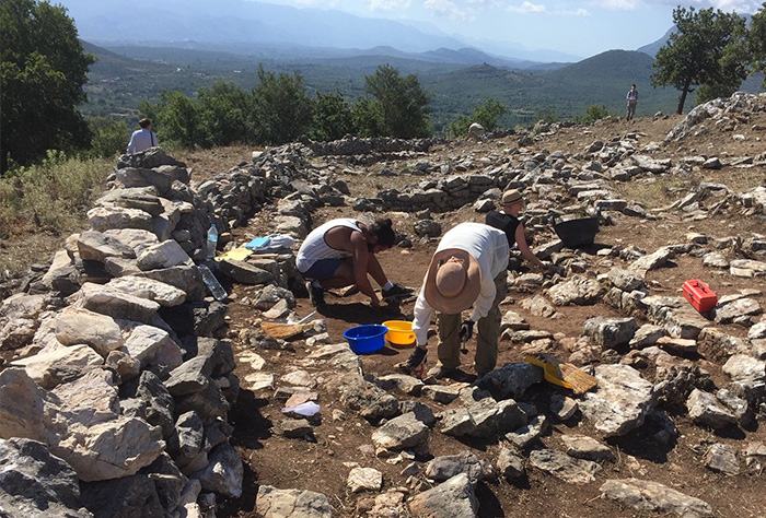
Fig. 3: Work during the recent excavations at the Malthi settlement.
In 2016, work continued with the photography of the settlement using an aerial drone, carried out by Daniel Löwenborg and Karl-Johan Lindholm. The imagery resulted in two 3D-models, the first covering the Ramovouni hill and adjacent valley floor and the second the preserved architecture within the fortification. During the 2016 season, small-scale test trenches were also opened in order to better explore the stratigraphy of the village, and particularly of the fortification wall. The goal was to determine the date of the construction of the settlement and the fortification wall, using both the ceramic sequence and carbon dating of bone fragments. To that end, three trenches were opened, two along the exposed faces of the fortification at the north, both on the interior and exterior, and one additional trench at the northeast on the exterior of the fortification wall. The additional trench was not successful in locating the exterior face of the wall in this area, but in the other two trenches it was possible to study a relatively well-preserved section of the fortification, about 3 m in width, 1,2 m in height, and around 5 m in length. This stretch of the fortification provided some details about the construction methods and process, including the foundation of the wall on bedrock and a likely retaining function. Most importantly, a level probably to be associated with the construction of the fortification wall was found along the exterior at the north.
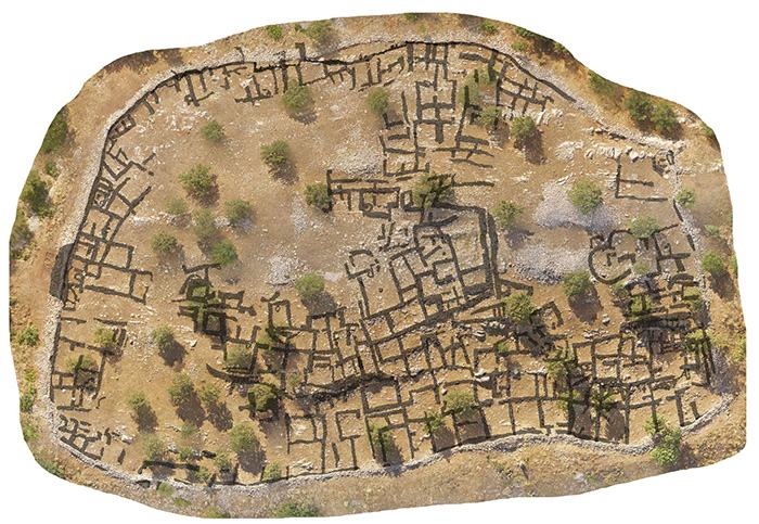
Fig. 4: Plan over the Malthi settlement.
In 2017 excavation continued in the previously opened trench along the interior of the fortification wall at the north. This trench was meant to explore two rooms of a likely domestic space, and the excavations reached a level that may predate the construction of the fortification wall prior to hitting bedrock. Two additional trenches were opened inside the settlement. The new trenches were selected in order to compare the stratigraphy in other portions of the site with that discovered at the north in the previous season. One was in the central part of the site – in Valmin’s industrial area – and one was along the interior of the western fortification wall. In general, as Valmin suggested, much of the settlement appears to have been built at once, founded on similar layers of infilling meant to create a level surface over uneven bedrock outcroppings. In addition to domestic debris, a number of burials were also excavated. The discovery of these burial, most of which were not documented during the original excavation, suggests that in many places Valmin had not dug down to bedrock and confirms that at least portions of the settlement stratigraphy were undisturbed by the previous excavation. Micromorphological samples were therefore taken from these areas. Alongside the work in the field, a restudy of the finds from Valmin’s original excavation was undertaken along with the examination of the ceramics recovered during the 2016–2017 excavations.
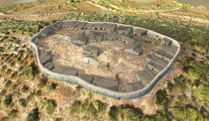
Fig. 5: 3D-reconstruction of the settlement shortly after the construction of the fortification wall, including several domestic structures, a central (administrative?) building, a possible burial monument and terraces.
Bibliography
Worsham, R., M. Lindblom & C. Zikidi 2018. ‘Preliminary report of the Malthi Archaeological Project, 2015–2016’, Opuscula 11, 7–27.
Blitzer, H. 1991. ‘Middle to Late Helladic Chipped Stone Implements of the Southwest Peloponnese. Part I: The Evidence from Malthi”, Hydra 9, 1–73.
Leuven, J.C. van. 1984. ‘The Sanctuaries of Malthi”, Scripta Mediterranea 5, 1–26.
Valmin, N. 1953. ‘Malthi-epilog, vorläufiger Bericht über die Schwedische Ausgrabung in Messenien 1952’, Opuscula Atheniensia I, 29–45.
Valmin, N. 1939b. Das adriatische Gebiet in Vor- und Frühbronzezeit (Lunds universitets årsskrift; första avdelningen, Teologi, juridik och humanistiska ämnen), Lund.
Valmin, N. 1938. The Swedish Messenia expedition (Acta Regiae Societatis humaniorum litteranum Lundensis), Lund.
Valmin, N. 1937a. ‘Poids préhistoriques grecs de Malthi en Messénie”, Bulletin de la Société royale des Lettres de Lund 1936-1937, 29–72.
Valmin, N. 1937b. ‘Céramique primitive messénienne’, Bulletin de la Société royale des Lettres de Lund 1936- 1937, 133–160.
Valmin, N. 1934. ‘Rapport préliminaire de lʼexpédition en Messénie 1933”, Bulletin de la Société royale des Lettres de Lund 1933-1934, 9–24.
Valmin, N. 1935. ‘Rapport préliminaire de lʼexpédition en Messénie 1934”, Bulletin de la Société royale des Lettres de Lund 1934-1935, 1–52.
Valmin, N. 1930. Etudes topographiques sur la Messénie ancienne, Lund. 1931. Aten genom tiderna, Stockholm.
Valmin, N. 1928. ‘Continued explorations in Eastern Triphylia”, Bulletin de la Société royale des Lettres de Lund 1927-1928, 171–224.
Valmin, N. 1927. ‘Two tholos tombs at Bodia in the eastern part of Triphylia”, Bulletin de la société Royale del lettres de Lund 1926-1927, 53–89.
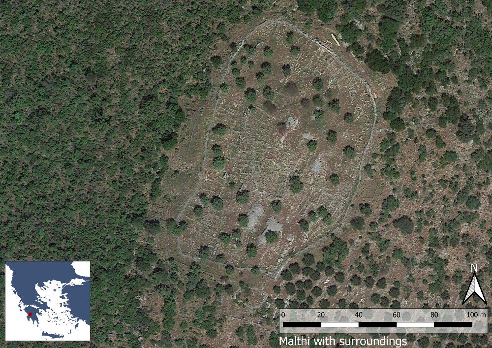
Fig. 1: Map over the fortified settlement of Malti (Basemap: Google maps satellite image).
Printed: 2026-06-16
From the web page: Swedish Institute at Athens
https://www.sia.gr/en/sx_PrintPage.php?tid=319