Swedish archaeologists have conducted fieldwork in and around the Berbati valley in the Argolid on the Peloponnese since the 1930s. Initially work was focused on excavations in the western part of the Berbati valley itself, but later the investigations came to incorporate also the Limnes and Miyio valleys located to the east. The investigated area is encircled by tall mountains and clearly delimited from its surroundings. To the south, over the mountain ridge of Euboia lies the plain of Argolis and to the west Mycenae is reachable through a pass between the mountains Zara and Profitis Elias. To the north and over the Psili Rachi lies the valley of Ayonori while the area to the east of the Limnes and Miyio valleys is dominated by tall mountains. Due to the location between Corinth and the Argolid, the three valleys have been described as a border region, dominated by one or the other of the two cities throughout the millennia.
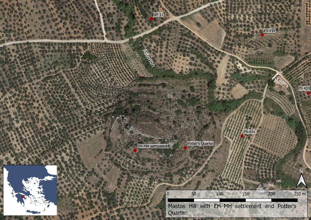
Swedish fieldwork in Berbati was instigated in 1934 when Axel W. Persson, Gösta Säflund and Erik J. Holmberg travelled there in search for potential excavation sites and located the promising prehistoric site of Mastos (with the help of Persson’s foreman at Dendra). The following year Persson excavated the tholos tomb (Findspot 515) while Holmberg investigated a chamber tomb (Findspot 514). In 1936 Persson and Åke Åkerström began to explore the east slope of the Mastos hill, later known as the Potter’s Quarter. Persson also made trial trenches in the Roman Bath (Findspot 500). Säflund on the other hand explored the Western Necropolis to the north-west of Mastos. In 1937 Säflund shifted his focus to the south slope of Mastos where he located an Early to Middle Helladic settlement. Persson continued working at the Potter’s Quarter 1937–1938. After these initial excavations, work in the valley was not reassumed until after World War II when Åkerström continued his investigations at Mastos in 1953, with a short final season in 1959.

Fig. 2: The settlements on the Mastos hill (Basemap: Google maps satellite image).
The Swedish fieldwork in Berbati was reassumed on a large scale by Berit Wells in the late 1980s. In 1988–1990 she executed a surface survey of the valley as well as the mountainous area around the village of Limnes to the east. The project successfully embraced a long-term perspective and Wells had the team collecting material dating from prehistory until the early 19th century, thereby ensuring an unusually long term view of the development in the area.
From 1994 onwards several sites located during the survey were investigated or underwent further documentation within the Berbati Valley Project, which aimed to investigate the agrarian economy of the valley. In 1994 a Late Geometric–Archaic cult place at the tholos tomb was excavated, in parallel with a study of the Late Roman bath. From 1995 the project focused entirely on the agrarian economy of the valley. Although several targets had been chosen for excavation only one at Pyrgouthi (Findspot 506, the Hellenistic Tower) could be realized. The Berbati Valley Project was brought to conclusion in 1999 with an intensive survey of the Mastos Hill, which had been excluded during the 1988–1990 survey. The aim of the 1999 survey was to test new methods of field sampling and digital processing of data.
The earliest remains in the Berbati and Limnes valleys date from the Middle Palaeolithic (c.100.000–35.000 BC) period, with a limited number of flaked stone tools suggesting frequent human visits over a long period of time. The most important find from the period was a stone core and flakes found in a layer of paleosol, ancient soil, exposed by a stream (Findspot 600). Then a distinct decline in material is noticeable during the Upper Palaeolithic period (c. 30.000–11.000 BC), represented only by two finds, a backed blade and an end scraper. The lack of a human presence at this time may be explained by the occurrence of the glacial maximum c. 18.000 BC, probably making the ancient coastal plain more attractive. During the Mesolithic two sites from c. 11.000–10.000 BC are attested (Findspots 200 and 201), both located under vertical lime stone cliffs in the Klisoura pass. From this position the sites were well placed to take advantage of the animals and plants along the homonymous stream running there.
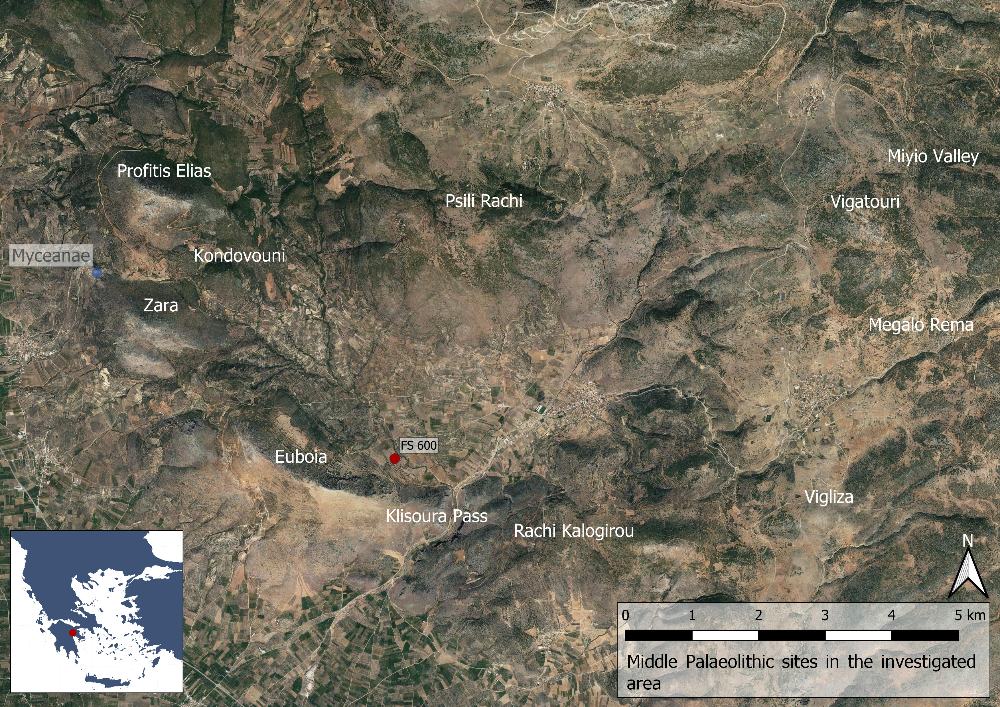
Fig. 3: Middle Palaeolithic sites in the Berbati, Limnes and Miyio valleys (Basemap: Google maps satellite image).
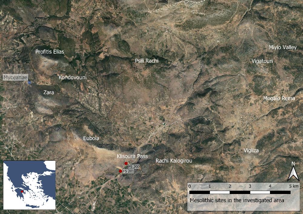
Fig. 4: Mesolithic sites in the Berbati, Limnes and Miyio valleys (Basemap: Google maps satellite image).
Following the abandonment of the Mesolithic sites no human activity can be ascertained before the Early and early Middle Neolithic period (c. 6000–4500 BC) when a large settlement existed in the valley. The site was later reoccupied in the Late and Final Neolithic period (c. 4500–3000 BC). This was, however, not the only settlement during the very end of Neolithic times; in total six sites from the period were found in the Berbati valley and another 13 in the rest of the surveyed area. These sites were agricultural in nature or made for special purposes, with evidence suggesting sheep and goat herding. There is also evidence of a site hierarchy with one site being centrally located in each of the Berbati, Limnes and Miyio valleys respectively (Findspots 400, 39 and 12).
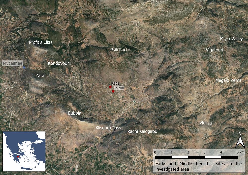
Fig. 5: Early and Middle Neolithic sites in the Berbati, Limnes and Miyio valleys (Basemap: Google maps satellite image).
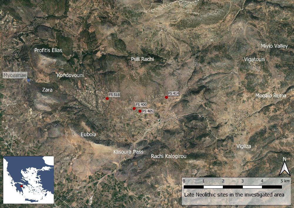
Fig. 6: Late Neolithic sites in the Berbati, Limnes and Miyio valleys (Basemap: Google maps satellite image).
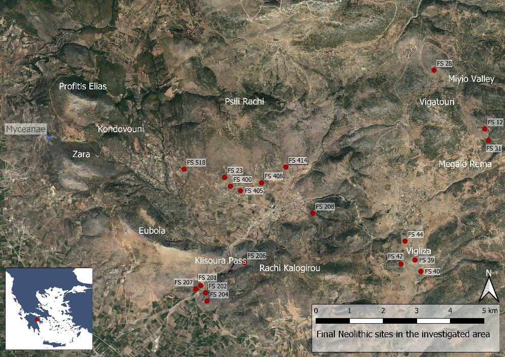
Fig. 7: Final Neolithic sites in the Berbati, Limnes and Miyio valleys (Basemap: Google maps satellite image).
From the Early Helladic period (c. 3100–2000 BC) 21 sites are known. Three of these (Findspots 39, 40 and 518) were particularly rich in material from Early Helladic I (c. 3100–2700 BC). In the following period, Early Helladic II (c. 2700–2200 BC) three other sites became important (Findspots 12, 405 and 414). In the Berbati valley habitation was concentrated to the southern slope of Psili Rachi. This had several advantages: the location offered plenty of sunlight compared to the slopes of Euboia, it was easy to see anyone entering the valley from the Klisoura pass, and the fertile valley floor could be used for agriculture. A number of saddle querns, mortars and handstones further strengthens the view that the inhabitants lived of agriculture. In the Limnes valley, settlements were concentrated around the Vigliza and finds similar to those in Bertabi suggests further agriculture here, albeit using more marginalized lands. In the Miyio valley a settlement was located at Findspots 12 and 13, producing evidence of both agriculture and craft specialization.
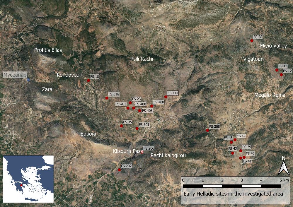
Fig. 8: Early Helladic sites in the Berbati, Limnes and Miyio valleys (Basemap: Google maps satellite image).
One site on the southern slope of the Mastos hill, from the Early and Middle Helladic (c. 3100–1600 BC) period has been particularly well explored through excavations and later surveys. It is located in the centre of the Berbati Valley, c. 4 km to the east of Mycenae, beside the Asterion stream. The excavations at the Early Helladic (c. 3100–2700 BC) settlement revealed two house complexes, a stone pavement and several bothroi (pits for votive offerings). In one of these complexes, House R–B, a human skeleton and bronze dagger was found, while house N-P contained three pithoi (large storage vessels) in situ as well as fragments of two more. This early settlement was destroyed during Early Helladic III (c. 2200–2000 BC) by a large fire, producing a 20–30 cm thick destruction layer. The following Middle Helladic settlement was considerably less well preserved with some wall fragments and ceramic material, as well as two tombs.
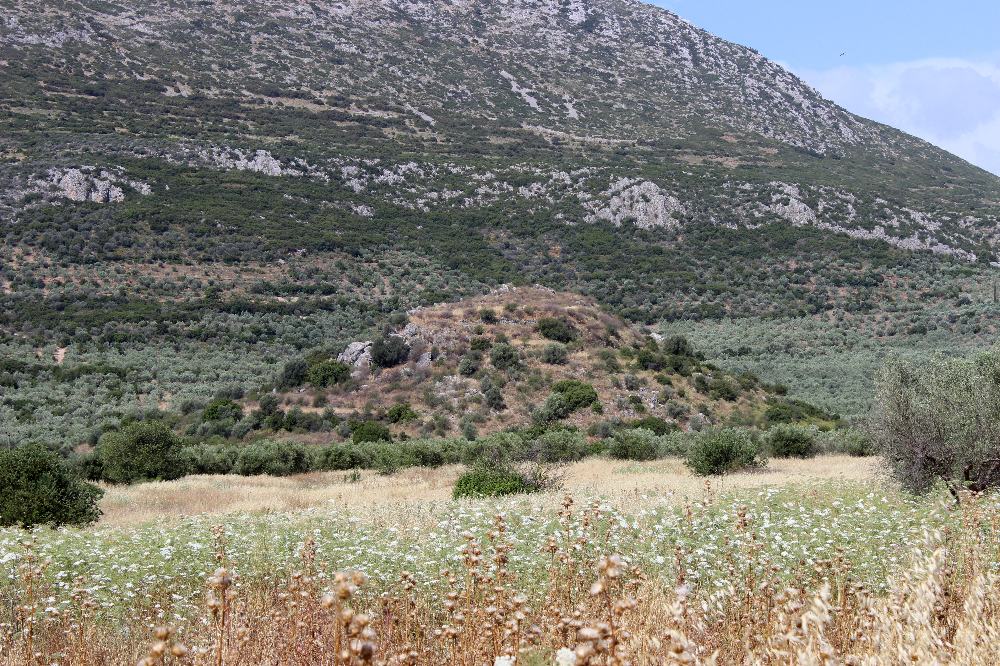
Fig. 9: The Mastos hill.
In Late Helladic I (c. 1600–1500 BC) only the Mastos Hill was inhabited and it has been suggested that Berbati was a small but independent chiefdom, based on the presence of a tholos tomb (Findspot 515). Following this period, the material indicates an activity peak between LH IIIA2 late (c. 1370–1300 BC) and LH IIIB (c. 1300–1190 BC) with a distinct shift in the site pattern towards the west side of the valley. Of the settlements Findspot 14 was the largest site by far, measuring 6 ha. In comparison, the second largest one is only 0.4 ha (Findspot 44). The graves are dominated by chamber tombs, many of which have been destroyed by modern agricultural activity. After LH IIIB there is a sharp decline in material from LH IIIB2, continuing into the subsequent LH IIIC. This suggests that the prosperity of the valley was closely tied to that of Mycenae, to which it exported products such as food, wool and pottery. A road (one of its bridges can be seen at SM 2) facilitated the transportation of goods from Berbati to Mycenae.
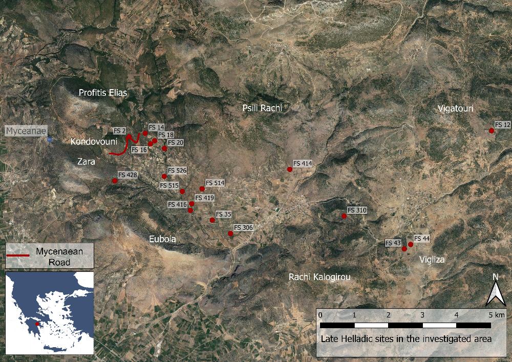
Fig. 10: Late Helladic sites in the Berbati, Limnes and Miyio valleys (Basemap: Google maps satellite image).
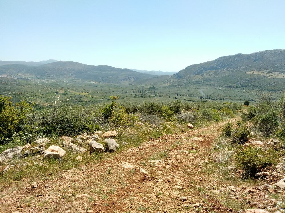
Fig. 11: Mycenaean road leading into the Berbati valley.
The tholos tomb (Findspot 515) is located c. 500 m north of the Mastos hill and constructed into a steep poros-stone hillside. Its dromos, entrance way, was 8 m long and 2.5 m wide with walls made of flat lime stones. The stomion, door-way, is over 3 m tall and almost 4 m deep, with a width of between 1.40 and 1.70 m. The outer face of the stomion was made of well-cut poros blocks, producing a monumental façade. When found the door-way was still sealed by a rubble-stone wall. The tholos itself, the bee-hive shaped chamber, measured 8 m in diameter. Although the upper part of the tholos collapsed as early as Geometric times (c. 900–700 BC), studies suggest that it was once about 8 m tall. The floor was covered by plaster with an opening for a single interment. Although the tomb had been plundered in antiquity, the find of Palace Style pottery as well as other ceramics makes it possible to date the tomb to LH II (c. 1500–1390 BC). Pottery of Late Geometric (c. 760–700 BC) and Late Roman date (c. 300–500 AD) attest to the reuse of the tholos as a cult place in later periods.
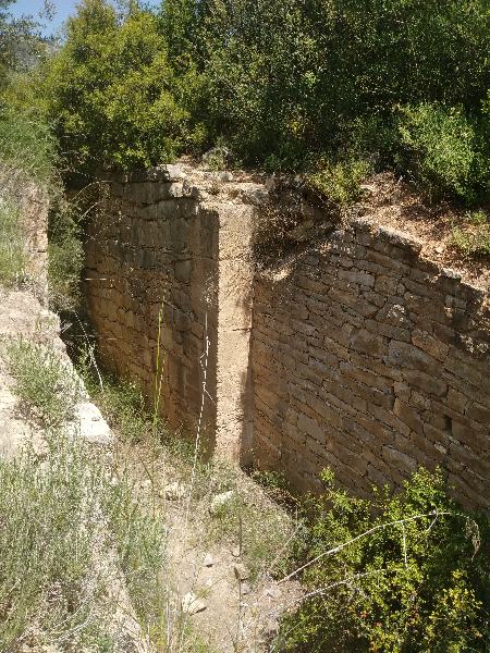
Fig. 12: Late Helladic II Tholos in the Berbati valley.
As in Early and Middle Helladic times the Mastos hill was inhabited during the Late Helladic period (c. 1600–1070 BC). However, now the activity took place at the so-called Potter’s Quarter on the eastern slope. The most spectacular structure here was the kiln and two pottery dumps, dated to the transition between LH II and LH IIIA1 (c. 1400 BC). Analyses of the fabrics have shown that the clays are consistent with those in the general area of Berbati and Mycenae, i.e. locally mined. In contrast to this, the vessels produced at Mastos have been found as far away as on Cyprus and in the Levant.
Following the Late Helladic period (c. 1600–1070 BC) the investigated areas were all but abandoned, with extremely few finds. There are only two exceptions: an unpublished group of vessels from a tomb at an unknown location dating to Early Geometric II (c. 875–850 BC) and a second tomb containing a large number of vessels dating to Middle Geometric I (c. 850–800 BC). It is not until c. 750 BC that there is renewed activity in the Berbati valley. This is, however, concentrated in a relatively small area to the north-west with Findspots 20 and 24 being the most important. In the east, the Limnes area, the material is too scattered to be considered evidence of settlements. Overall the material has suggested to scholars that the area was resettled by people living around Mycenae.
The pattern during the Early and Middle Archaic period (c. 700–525 BC) closely follows that during Late Geometric (c. 760–700 BC) times, although with less material spread over a larger number of findspots. This has been interpreted as a potential sign of a population decline or methodological difficulties identifying the local Archaic pottery. Some earlier sites also remain inhabited, e.g. Findspots 20 and 24. The material from the Late Archaic times (c. 525–480 BC) indicates a distinct population increase.
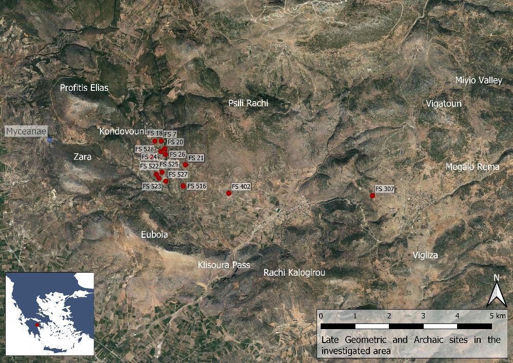
Fig. 13: Late Geometric and Archaic sites in the Berbati, Limnes and Miyio valleys (Basemap: Google maps satellite image).
One of the most important sites of the Late Geometric and Archaic period was the cult at the LH II tholos. The material here suggests that the area of the tomb was reused as a religious site from Late Geometric II (c. 735–700 BC) to the end of the 6th century BC. While the exact nature of the cult is unknown it is usually interpreted as a hero or tomb cult. Similar cults in old tholos tombs are well known from other areas of the Argolis as well as the rest of the Mycenaean world.
After the population decline in the Late Archaic period it seems that a major resettlement took place around the middle of the 5th century BC. At first the central area of the Berbati Valley was occupied (east of the Later Roman bath) with one distinct site (Findspot 426) to the west. Two of the sites from the period (Findspots 405 and 406) may have formed a place of refuge in times of crisis. There was considerably less activity in the Limani valley to the east, which however included a fortress at Findspot 42 on the Vigliza Hill. A peak in habitation takes place in the late 4th and early 3rd century BC with increased settlement density in the already settled area, as well as new sites to the west on both sides of the Kephalari Rema gorge. There were also a few sites around the Mastos hill.
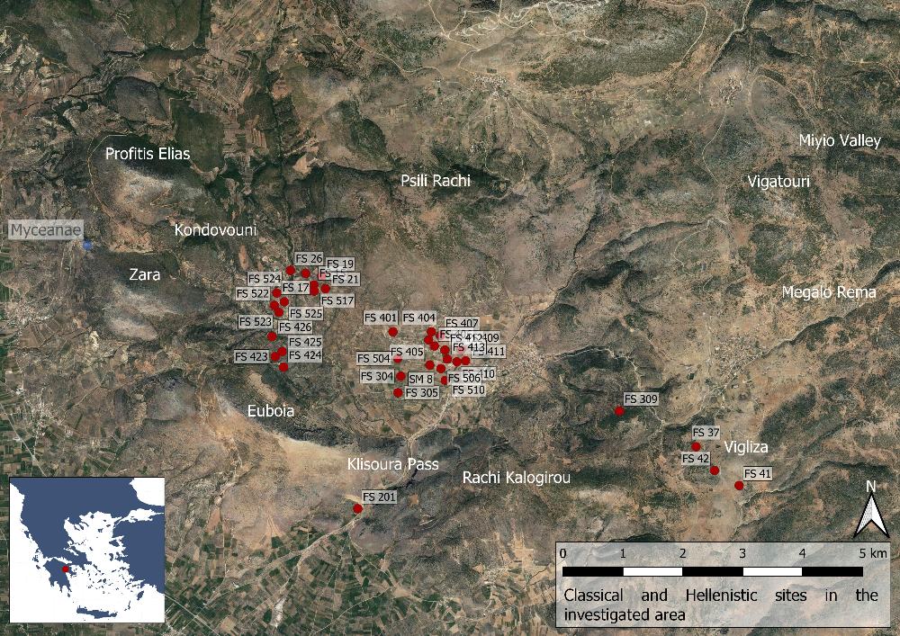
Fig. 14: Classical and Hellenistic sites in the Berbati, Limnes and Miyio valleys (Basemap: Google maps satellite image).
Overall the evidence suggest that the sites were agricultural in nature with few exceptions, such as the refugee at Findspots 405 and 406 and the Vigliza Fortress at Findspot 42. Some other exceptions are two potential sanctuaries (Findspot 409 and one at the modern cemetery east of the Roman Bath) as well as three towers (Findspots 19 and 506, and Standing Monument 8) probably constructed around 300 BC. They measure 6×6 m and were constructed in a rough polygonal masonry style. One of these, the Pyrgouthi tower (Findspot 506) was excavated in order to explore the agricultural activity in greater depth than what is possible through a survey. The investigation revealed stray finds from the Bronze Age, while the earliest settlement at the tower dated to the Early Iron Age (c. 900–850 BC BC, possibly continuing into the Early Archaic period (c. 700–600 BC). From the following period, two pottery kilns, used in the 5th century BC but quickly abandoned, have been identified. The tower remains visible today were constructed around 300 BC, but did not remain in use for long as shown by the lack of many of the most typical Hellenistic (323–31 BC) types of pottery. At the end of the 1st century BC the tower was refurbished and a building with relatively large rooms constructed immediately to the west. As with the pervious phases, this did not last long. Finally the tower was resettled in Late Antiquity when it was turned into a large farm house sometime between the 6th and mid-7th century AD.
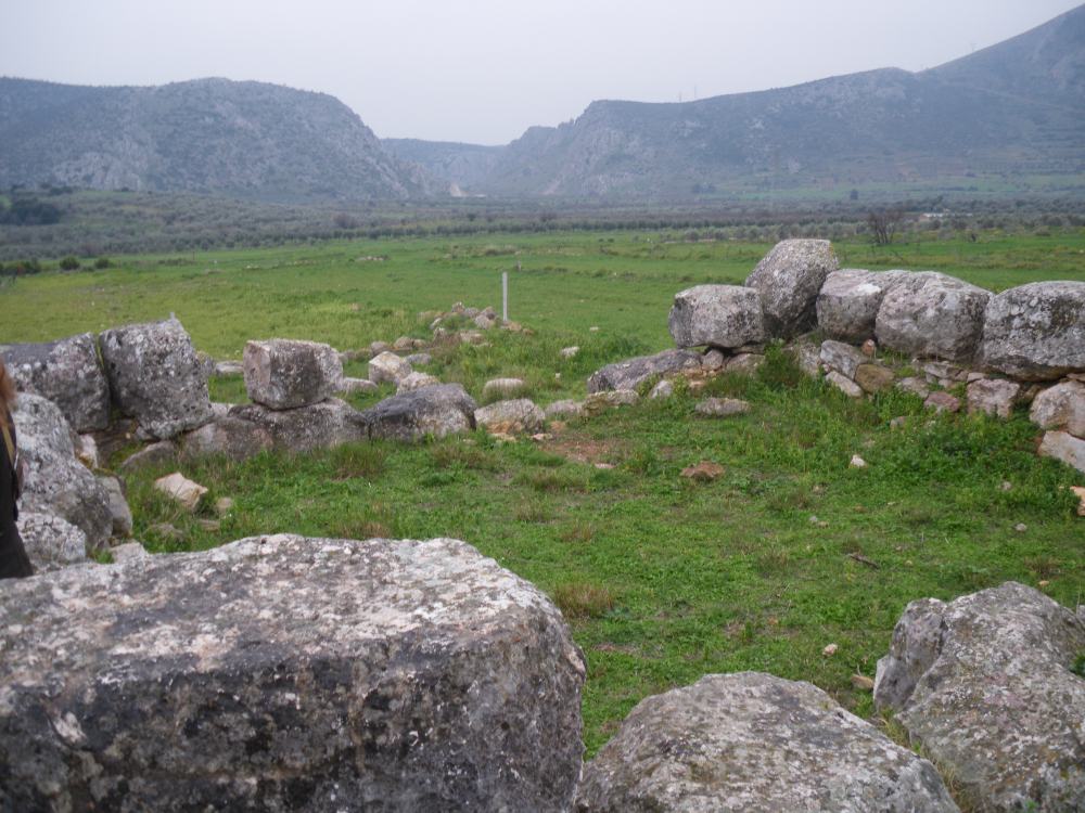
Fig. 15: Pyrgouthi tower in the Berbati valley, c. 300 BC (Find Spot 506).
From the 2nd century BC onwards there is again a general decline in the number of sites within the surveyed area. The earliest Roman material dates to the 1st century AD, with a majority of the finds however stemming from the 4th century AD and continuing into the 6th century AD. In general, the activity patter during these centuries reflect those in other areas of Greece at the time. In Early and Middle Roman times (late 1st century BC–3rd century AD) urban living was probably preferred while tenants or slaves worked the land. This changed in Late Roman times (c. 300–500 BC) when life in rural villas became more popular, in tandem with the development of a serf class.
In terms of settlement pattern it is clear that the Roman sites were mainly situated on the valley bottom, not the hill slopes as in earlier periods. The largest site is a villa covering 450×250 m with auxiliary facilities located around the still visible Roman bath situated in the centre of the valley. There is moreover evidence of a farm complex with one or more farmsteads in the west area of Berbati, around Findspot 522. Another farm was probably located on the other side of the gorge at Findspot 517 and evidence of Late Roman industrial activity in the form of a possible water mill at Findspot 420 was identified near Mastos. Such a large investment suggests that the agricultural output in the valley was substantial.
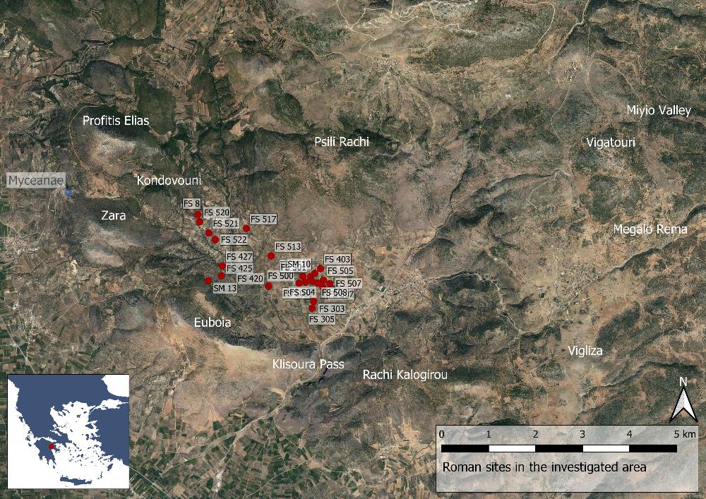
Fig. 16: Roman sites in the Berbati, Limnes and Miyio valleys (Basemap: Google maps satellite image).
Among the identified sites, three preserved Roman buildings stand out: the bath (FS 500), a large reservoir (SM 10, often mistakenly called a cistern) as well as a Hypogaeum (SM 13). The bath was identified as such by the finds of spacer pins in the area, used to fasten tiles at a distance from the wall in order to let warm air through. Constructed around 300 AD, the current remains stand c. 3 m high, with another 2.5 m hidden under the modern ground surface. Originally the structure may have been almost 10 m in height and covered an area of at least 25×25 m. As was common for Roman baths it was constructed of bricks with a cement and rubble core, while the walls were covered with frescos and the floors decorated with polychrome mosaics, which together created an opulent atmosphere. Nearby, at Findspot 503, remains of mosaics, opus sectile slabs as well as painted wall fragments indicate that this was the location of the living quarters of the villa to which the bath belonged. Presumably the villa continued to the north where a part of a mosaic floor can be seen in the Chapel of Ag. Ioannis (Findspot 502).
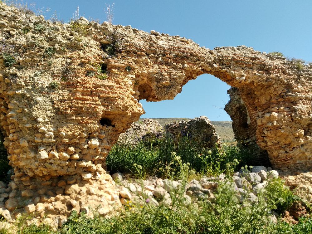
Fig. 17: The Roman bath in the Berbati valley.
The reservoir (SM 10) is located c. 350 to the north of the bath and at a 20 m higher elevation. Measuring 30×17 meters with walls preserved up to a height of 3.6 m, it could hold a volume of almost 2000 m3. On the outside several arches were constructed in order to hold back the pressure on the walls, while the inside was equipped with at least two layers of waterproof lining. Water was supplied through a terracotta pipeline, presumably from a nearby spring.
The Hypogaeum is located in the west part of the Berbati Valley, just to the west of the Panaghia church. The structure consists of two chambers which were once roofed. The first was presumably an antechamber as the second contained five rock-cut cist burials. When initially investigated by Persson in the 1930s the remains of 24 individuals were found. Although the burials were plundered, some artefacts remained, such as a bronze ring, some lamps and a few vases. Further cuttings in the bedrock in the area may be the remains of other, now completely destroyed, tombs.
Between c. 500 and 700 AD the occupation remained on the bottom of the valley, close to water sources, and most of the sites had a Roman background. The Roman villa near the bath survived, albeit on a smaller scale. Most of the new sites, such as e.g. Findspots 36, 404 and 511, were located close to older sites. It therefore seems like old habitation patterns largely continued. However, a lack of fine ware pottery suggests that the valleys were now becoming increasingly isolated. The material from the following four centuries (c. 700–1100 AD) indicates considerably less activity, although there are indications of resettlement in the Miyio valley. This general decline has been connected to the tumultuous picture of the times provided in historical sources with plagues, hostile invasions and the threat of pirates.
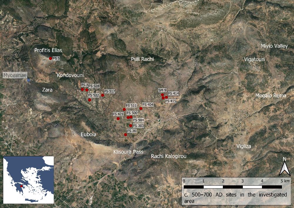
Fig. 18: Sites from c. 500–700 AD in the Berbati, Limnes and Miyio valleys (Basemap: Google maps satellite image).
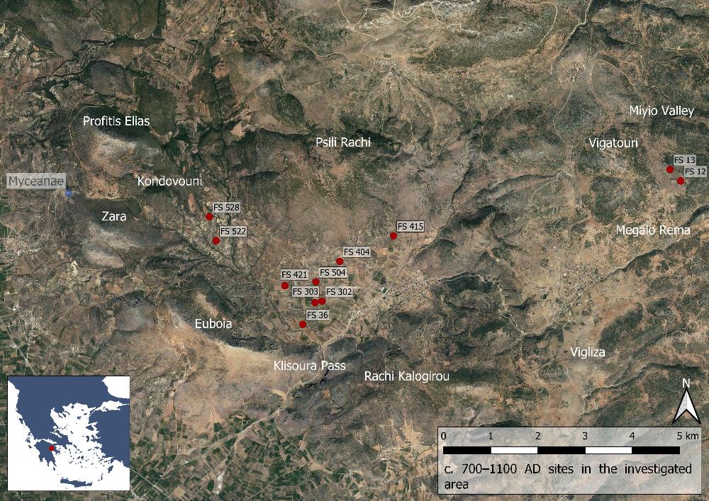
Fig. 19: Sites from c. 700–1100 AD in the Berbati, Limnes and Miyio valleys (Basemap: Google maps satellite image).
Around 1100 AD the fortunes of the Berbati area turned around. This may be connected to Corinth becoming the capital of the Byzantine theme (the primary military and administrative division in Middle Byzantine times) of the Peloponnese during the 9th century AD, the prosperity of which slowly spread in the area. In the Berbati valley the bottom was still the preferred area of habitation, but most sites were now located slightly further west than in previous centuries. The settlements also appear to be generally larger in size and include more findspots. In the Miyio valley one single settlement, Findspot 13, dominated the area. The economy in the region seems to have been based on grain production as testified by the finds of many querns, while some olive presses testifies to the production of oil.
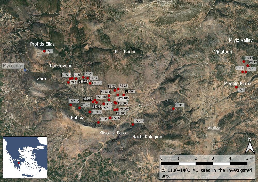
Fig. 20: Sites from c. 1100–1400 AD in the Berbati, Limnes and Miyio valleys (Basemap: Google maps satellite image).
Sometime after 1400 AD the fortunes of the valley turn again. In the western part of the valley only Findspot 17 continues into the 15th century AD, while the survival of Findspots 3, 4, 6, and 519 are less secure. The old village around Findspot 418 was slowly abandoned until it became desolate around 1700 AD as the villagers fled to the tree-covered area around modern Prosimna. The changes between c. 1400 and 1700 AD may be largely related to the many wars during the period, often with the frontlines around the Berbati area. There were, however, also new population groups. For example, around 1400 AD Albanians were granted passage into the Peloponnese. Many of these probably settled in the investigated area as indicated by the fact that Arvanitika was still spoken there by the elderly until very recent time. Despite this influx of people, the Venetians, who controlled the Peloponnese during the late 17th century AD, were concerned by the general depopulation.
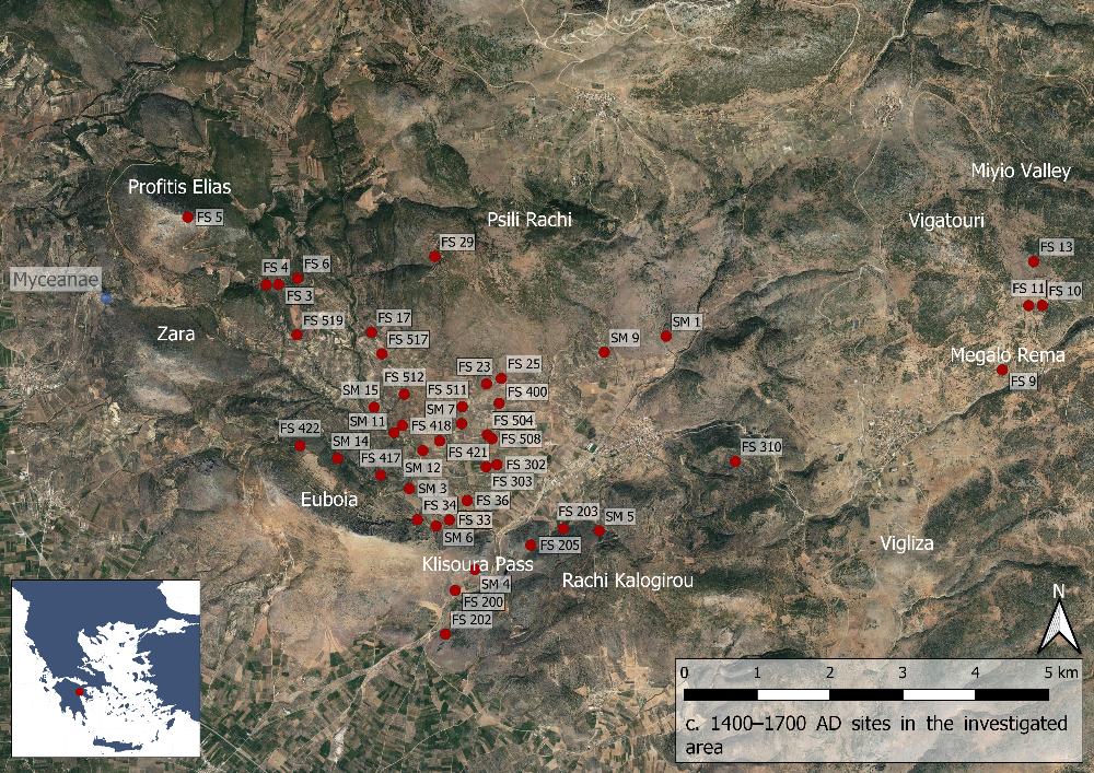
Fig. 21: Sites from c. 1400–1700 AD in the Berbati, Limnes and Miyio valleys (Basemap: Google maps satellite image).
During the 18th century a repopulation took place in the Berbati, Limnes and Miyio valleys with the area dominated by the villages of Prosimna and Limnes. During this period the valleys were under the control of Corinth, and the Berbati valley received its current name from the homonymous village, present day Prosimna. The finds from 1700 until the Greek revolution 1821 are scattered and may be considered as general background material rather than indication of habitation. Possibly the whole Berbati belonged to one large Turkish estate. At the time of the Greek War of Independence 1821–1829 the area is said to have belonged to a small number of individuals. In 1833 no more than 236 individuals lived in Berbati, while Limnes had a population of 859.
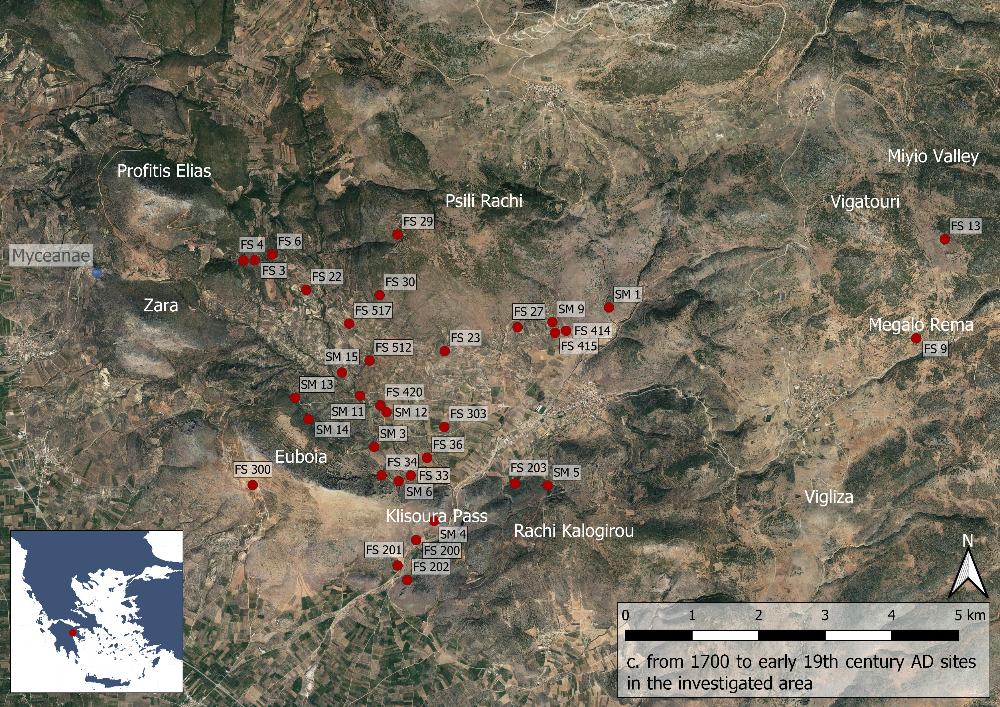
Fig. 22: Sites from c. 1700 AD to the early 19th century in the Berbati, Limnes and Miyio valleys (Basemap: Google maps satellite image).
Bibliography
Åkerström, Å. 1938 ‘Peloponnes. Berbati’, AA, 552–554, 557.
Åkerström, Å. 1940. ‘Das mykenische Törperviertel in Berbati in der Argolis’, in VI. internationaler Kongress für Archäologie, Berlin 21–26. August 1939, Bericht, Berlin, 296–298.
Åkerström, Å. 1952. ‘En mykensk krukmakares verkstad. Från de svenska utgrävningarna
i Grekland åren 1935–1938’, in Arkeologiska forskningar och fynd. Studier utgivna med anledning av H.M. Konung Gustaf VI Adolfs sjuttioårsdag 11.11. 1952, Stockholm, 32–46.
Åkerström, Å. 1968 ‘A Mycenaean potter’s factory at Berbati near Mycenae’, in Atti
e memorie del 1° congresso internazionale di micenologia Roma 27 settembre–3 octobre 1967, 1 (Incunabula Graeca, 25:1), Roma, 48–53.
Åkerström, Å. 1992. ‘Furumark’s type 279 - a reality or not?’, OpAth 19, 163-166.
Åkerström, Å. 1987. Berbati. Vol. 2. The pictorial pottery (ActaAth-4°, 36), Stockholm.
Ekroth, G. 2013. ‘Between bronze and clay. The origin of an Argive, Archaic votive shape’, in Forgerons, élites et voyageurs d’Homère à nos jours. Hommages en mémoire d’Isabelle Ratinaud-Lachkar (La pierre & l’écrit), eds. M.-C. Ferriès, M.P. Castiglioni & F. Letoublon, Grenoble, 63-77.
Forsén, J. 2002. ‘The Early Bronze Age at Berbati’, in New research on old material from Asine and Berbati. In celebration of the fiftieth anniversary of the Swedish Institute at Athens (ActaAth-8°, 17), ed. B. Wells, 2002, 135–139.
Holmberg, E.J. 1983. A Mycenaean chamber tomb near Berbati in Argolis (Acta Regiae Societatis scientiarum et litterarum Gothoburgensis. Humaniora, 21), Göteborg.
Hjohlman, J. A. Penttinen & B. Wells 2005. Pyrgouthi: a rural site in the Berbati Valley from the Early Iron Age to Late Antiquity. Excavations by the Swedish Institute at Athens 1995 and 1997 (ActaAth-4°, 52), Stockholm.
Person, A.W. & Å. Åkerström 1938. Zwei mykenische Hausaltäre in Berbati (Kungl. Humanistiska vetenskapssamfundets i Lund årsberättelse 1937/1938:3), Lund.
Petrović, N. 2009 ‘Mycenaean animal figurines from Mastos, Berbati’, in Encounters with Mycenaean figures and figurines. Papers presented at a seminar at the Swedish Institute at Athens, 27–29 April 2001 (ActaAth-8°, 20), ed. A.-L. Schallin in collaboration with P. Pakkanen, Stockholm, 77–84.
Säflund, G. 1965. Excavations at Berbati 1936-1937 (Stockholm studies in classical archaeology, 4), Stockholm.
Schallin, A.-L. 1997. ‘The Late Bronze Age potter’s workshop at Mastos in the Berbati Valley’, in Trade and production in premonetary Greece. Production and the craftsman. Proceedings of the 4th and 5th International Workshops, Athens 1994 and 1995 (SIMA-PB, 143), eds. C. Gillis, C. Risberg & B. Sjöberg, Jonsered, 73–88.
Schallin 2002 A.-L. Schallin, ‘Pots for sale. The Late Helladic IIIA and IIIB ceramic production at Berbati’, in New research on old material from Asine and Berbati. Celebration of the fiftieth anniversary of the Swedish Institute at Athens (ActaAth-8º, 17), ed. B. Wells, Stockholm, 141–155.
Santillo Frizell, B. 1984. ‘The tholos tomb at Berbati’, OpAth 15, 24-55.
Wells, B. 1992. ‘Rapport från Berbati-Limnesprojektet’, Hellenika 60, 1992, 25–27.
Wells, B. 2002. ‘The kontoporeía. A route from Argos to Korinth’, in Ancient history matters. Studies presented to Jen Erik Skydsgaard on his seventieth birthday (ARID, Suppl. 30), eds. K. Ascani, V. Gabrielsen, K. Kvist & A. Holm Rasmussen, Roma, 69–76.
Wells, B. G. Ekroth & K. Holmgren 1996. ‘The Berbati Valley Project: the 1994 season. Excavations by the tholos tomb’, Opuscula Atheniensia 21, 189-209.
Wells, B. & M. Lindblom (eds.) 2011. Mastos in the Berbati valley: an intensive archaeological survey (ActaAth-4°, 54), Stockholm.
Wells, B. & C. Runnels 1996. The Berbati-Limnes archaeological survey 1988-1990 (ActaAth-4°, 44), Stockholm.
Wells, B., C. Runnels & E. Zangger 1990. ‘The Berbati-Limnes archaeological survey. The 1988 season’, OpAth 18, 207–238.
Weiberg, E. 2009. ‘Production of female figurines at Mastos, Berbati’, in Encounters with Mycenaean figures and figurines. Papers presented at a seminar at the Swedish Institute at Athens, 7–29 April 2001 (ActaAth-8°, 20), ed. A.-L. Schallin in collaboration with P. Pakkanen, Stockholm, 61–75.
Whitbread, I., M. Ponting & B. Wells 2007, ‘Temporal patterns in ceramic production in the Berbati Valley, Greece’, JFA 32, 177–193.
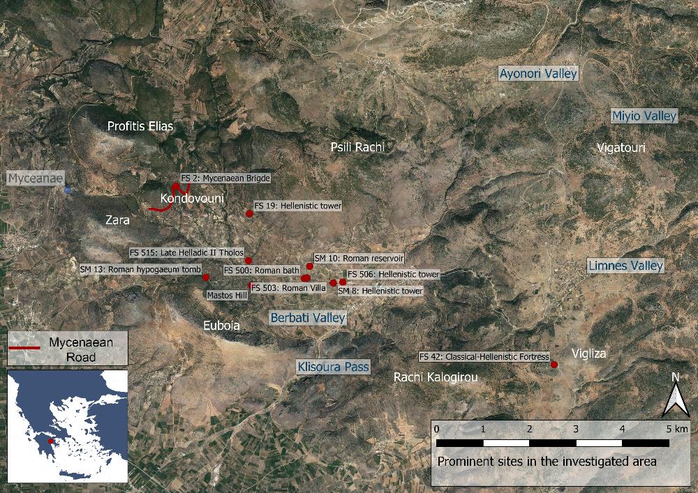
Fig. 1: Map over prominent sites in the Berbati, Limnes and Miyio valleys (Basemap: Google maps satellite image).
Printed: 2024-04-25
From the web page: Swedish Institute at Athens
https://www.sia.gr/en/sx_PrintPage.php?tid=367&export=html